
NumbersUSA published its first national level study on sprawl two decades ago in 2001. At that time, sprawl was a hot topic with many environmental organizations and the general public concerned about the impacts of ever-expanding cities and the nation’s steadily disappearing rural land. Vice-president and later presidential candidate Al Gore had made it a personal cause in the late 1990s. Two decades later, sprawl is still devouring valuable farmland and wildlife habitat throughout the United States, but national and state environmental groups, by and large, have shifted their focus away from domestic environmental and conservation issues toward more global issues like global warming and “climate justice”. The loss of habitat and open space due to the unsustainable outward expansion of cities in America, i.e., urban and suburban sprawl, has fallen out of fashion; it is no longer seen as “sexy.”
Despite our country’s economic setbacks since the Great Recession of 2008, sprawl continues to be a major threat to rural land and natural habitats in the United States. Nationally, in just the 10 years from 2007 to 2017, some 5,697,000 acres (about 8,900 square miles) – an area larger than New Jersey (8,723 square miles) – of previously undeveloped land succumbed to the bulldozer’s blade.
Although urban sprawl by name is not particularly salient in the news anymore, the results of sprawl continue to fuel numerous local controversies and are a factor in many of the nation’s most pressing environmental challenges. Americans remain concerned and would like these unfavorable trends halted or at least curbed.
The very first question in a May 2020 survey of 1,500 likely American voters revealed that 79 percent overall thought that the destruction of farmland and natural habitat because of urban sprawl was a “major problem” (44%) or “somewhat of a problem” (35%). In that fourth question of that same poll, when asked if it “is unethical to pave over and build on good cropland,” or if “the need to for more housing is a legitimate reason to eliminate cropland,” 62% responded that it is unethical to do so, more than three times the percentage (18%) who thought that the need for more housing is a legitimate reason.
44% A major problem
35% Somewhat of a problem
11% Not much of a problem
4% Not a problem at all
6% Not sure
In a June 2022 scientific opinion survey of more than 1,000 Colorado likely voters conducted by Rasmussen Reports for NumbersUSA, Coloradans expressed even greater concern about the loss of cropland than Americans in general did. Fully 94 percent of Coloradans indicated that it is “somewhat” or “very” important to protect farmland from development.
Government data show that the United States now has about one-third less cropland for each American than it did 30 years ago. How important is it to protect U.S. farmland from development so the United States is able to produce enough food to feed its own human population in the future?
76% very important
18% somewhat important
4% not very important
0% not at all important
2% not sure
By 2017, according to the most recent iteration of the National Resources Inventory (NRI), some 116,303,000 acres of land – 181,723 square miles – in the United States had been developed. This is an area nearly 20,000 square miles larger than the state of California (163,700 square miles), our third largest state. Only Alaska and Texas are larger. Another way of conveying the comparative extent of this developed land area is that it is approximately equal to the states of Maine, New Hampshire, Vermont, Massachusetts, Connecticut, Rhode Island, Delaware, New Jersey, New York, and Pennsylvania combined, that is, all of New England and much of the Mid-Atlantic States.
In the 35-year (1982-2017) period measured by the most recent National Resources Inventory (NRI), conducted by the United States Department of Agriculture’s (USDA) Natural Resources Conservation Service (or NRCS, formerly the Soil Conservation Service or SCS), approximately 69,000 square miles (44,175,300 acres) of open space, natural habitats, and farmland in the United States were converted into “Developed Land,” including housing, shopping malls, streets, schools, government buildings, utility infrastructure, waste treatment facilities, parking lots, vacation homes, resorts, highways, and places of work, worship, and entertainment. An area larger than Florida, our 22nd largest state, was “paved over” in just 35 years.
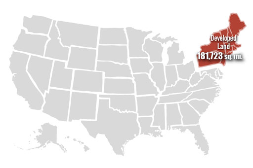
As of 2017, cumulative developed land in the United States is approximately equal to the combined area of those states shown in – Maine, New Hampshire, Vermont, Massachusetts, Connecticut, Rhode Island, Delaware, New Jersey, New York, and Pennsylvania
Of course, developed lands are not all contiguous in a single blob or polygon covering one part of the country and leaving the rest untouched, but are distributed unevenly in blotches and spots across the landscape.
Urbanized land areas, as defined and delineated for many years by the U.S. Census Bureau, are a similar category to NRI developed lands. The much greater extent of urbanization in the eastern USA and on East and West Coasts is quite evident on this map.
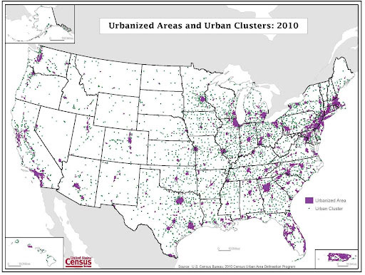
Urbanized Areas and Urban Clusters in the United States, 2010
Source: U.S. Census Bureau
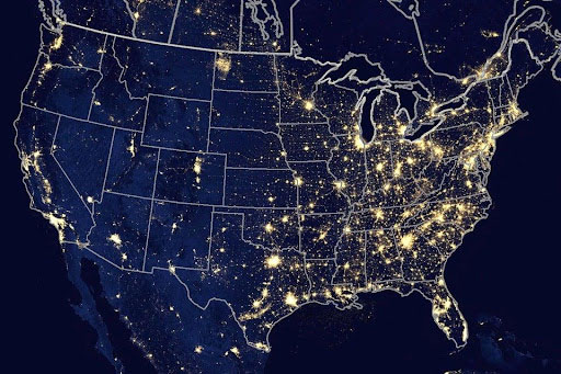
We can appreciate the degree to which urbanization has expropriated much of the American landscape by viewing a composite nighttime satellite image of the USA as a whole. One can see why astronomers say that residents of the United States east of the Mississippi River may live out their entire lives without ever once seeing the Milky Way, the galaxy in which we reside. This is due to the combination of the glow and glare from artificial lighting (light pollution) that cloak urbanized areas and the air pollution generated by the traffic, factories, and power plants associated with these areas. In contrast, less densely populated states like Arizona (outside of Phoenix and Tucson), blessed with dark and dry skies at night, away from its urban areas, are a blessing for astronomers and amateur stargazers who want to see, know, and appreciate man’s place in the universe.
Depicting all of America’s developed land as a single polygon, may also be misleading or deceptive if it gives the impression that the rest of the country, about 94 percent of it – now undeveloped lands or open space – is simply unused, empty, or wasted land that could be readily urbanized at no cost to society. In fact, most of these lands are already in use, serving valuable functions meeting the needs of urban residents for raw materials, food, fiber, water, watershed protection, energy, carbon sequestration, recreation, energy, and national defense, among other purposes.
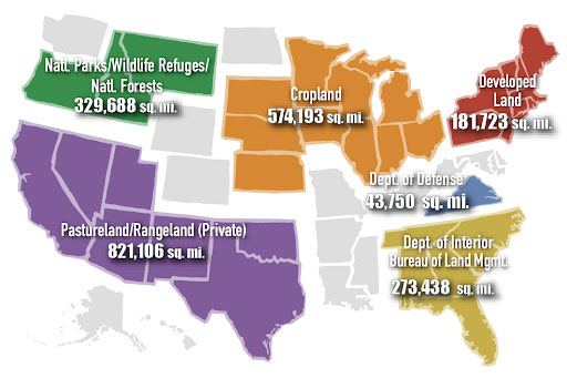
The image above, as noted, is not intended as a comprehensive inventory of all other official, designated, or recognized land uses in the USA. Rather, it is a mix of most public (federal, but not state, county, or local) and private land uses (privately owned cropland, pastureland, rangeland, but not forestland) which furnish Americans with valuable ecological services and economic goods and products.
For example, the U.S. Department of the Interior’s Bureau of Land Management manages some 273,438 square miles of land of the Lower 48 States – approximately equal in size to Tennessee, North Carolina, South Carolina, Georgia, Alabama, and Florida. These lands are used for livestock grazing, renewable and nonrenewable energy development, timber harvest, and many forms of outdoor recreation, all while “ensuring natural, cultural, and historic resources are maintained for present and future use,” according to the Bureau. Thus, it is a serious error to think of the approximately 94 percent of the land in the Lower 48 states that is now undeveloped as unused and or useless.
Which states have sprawled the most in recent decades? Texas, Florida, North Carolina, Georgia, and California are the top 5 sprawlers. Texas alone sprawled over 6,630 square miles in this time period, 52% more than the second-place state, Florida. Texans have witnessed and experienced this explosive growth firsthand. Colorado is ranked 21st nationally in terms of the amount of Open Space lost to urban sprawl and development from 1982 to 2017.
| Table 1. Sprawl in 49 States, 1982-2017, Ranked by Increase in Land Area | |||
|---|---|---|---|
| Sprawl Ranking 1982-2017 | State | Overall Sprawl (in square miles), 1982-2017 | |
| 1 | Texas | 6,634 | |
| 2 | Florida | 4,353 | |
| 3 | North Carolina | 3,996 | |
| 4 | Georgia | 3,910 | |
| 5 | California | 3,421 | |
| 6 | Pennsylvania | 2,686 | |
| 7 | Tennessee | 2,354 | |
| 8 | Michigan | 2,208 | |
| 9 | Virginia | 2,180 | |
| 10 | Ohio | 2,149 | |
| 11 | South Carolina | 2,136 | |
| 12 | Alabama | 2,023 | |
| 13 | Arizona | 1,744 | |
| 14 | New York | 1,642 | |
| 15 | Kentucky | 1,583 | |
| 16 | Washington | 1,436 | |
| 17 | Illinois | 1,332 | |
| 18 | Missouri | 1,329 | |
| 19 | Wisconsin | 1,261 | |
| 20 | Mississippi | 1,217 | |
| 21 | Colorado | 1,206 | |
| 22 | Indiana | 1,203 | |
| 23 | Louisiana | 1,192 | |
| 24 | Minnesota | 1,146 | |
| 25 | Oklahoma | 1,133 | |
| 26 | New Jersey | 1,077 | |
| 27 | Massachusetts | 1,038 | |
| 28 | Arkansas | 1,035 | |
| 29 | New Mexico | 1,019 | |
| 30 | Maryland | 877 | |
| 31 | West Virginia | 827 | |
| 32 | Utah | 713 | |
| 33 | Oregon | 688 | |
| 34 | Kansas | 627 | |
| 35 | Idaho | 583 | |
| 36 | Maine | 581 | |
| 37 | New Hampshire | 525 | |
| 38 | Nevada | 514 | |
| 39 | Iowa | 506 | |
| 40 | Montana | 416 | |
| 41 | Connecticut | 382 | |
| 42 | Nebraska | 270 | |
| 43 | South Dakota | 252 | |
| 44 | Wyoming | 251 | |
| 45 | North Dakota | 233 | |
| 46 | Vermont | 224 | |
| 47 | Delaware | 217 | |
| 48 | Hawaii | 136 | |
| 49 | Rhode Island | 99 | |
| Total | 68,560 | ||
Source: 2017 NRCS National Resources Inventory; Table 1
Note: Includes all states except Alaska; does not include territories
Urban Sprawl in Houston, Texas
In the most recent 15-year period, from 2002 to 2017, Texas and Florida maintained their top rankings, followed by Georgia (4th place from 1982-2017), California (5th place 1982-2017), and North Carolina (3rd place, 1982-2017). The top five states over the longer time frame are the same top five states in the most recent 15-year period, but with some shuffling of places. Once again, Texas was far and away the most sprawling state, with more than twice the area paved over with pavement than the 2nd-place state, Florida. Colorado is in 23rd place.
| Table 2. Sprawl in 49 States, 2002-2017, Ranked by Increase in Land Area | |||
|---|---|---|---|
| Sprawl Ranking 2002-2017 | State | Overall Sprawl (in square miles), 2002-2017 | |
| 1 | Texas | 2,616 | |
| 2 | Florida | 1,065 | |
| 3 | Georgia | 846 | |
| 4 | California | 831 | |
| 5 | North Carolina | 821 | |
| 6 | Virginia | 560 | |
| 7 | Arizona | 557 | |
| 8 | Tennessee | 534 | |
| 9 | Pennsylvania | 496 | |
| 10 | Ohio | 490 | |
| 11 | South Carolina | 487 | |
| 12 | Alabama | 481 | |
| 13 | Oklahoma | 431 | |
| 14 | Michigan | 426 | |
| 15 | Illinois | 391 | |
| 16 | Mississippi | 385 | |
| 17 | Missouri | 365 | |
| 18 | Wisconsin | 362 | |
| 19 | Louisiana | 362 | |
| 20 | Arkansas | 348 | |
| 21 | New York | 346 | |
| 22 | Indiana | 341 | |
| 23 | Colorado | 321 | |
| 24 | Kentucky | 311 | |
| 25 | Utah | 299 | |
| 26 | Washington | 288 | |
| 27 | Minnesota | 266 | |
| 28 | New Mexico | 232 | |
| 29 | Maryland | 192 | |
| 30 | Iowa | 189 | |
| 31 | Nevada | 181 | |
| 32 | Idaho | 176 | |
| 33 | Massachusetts | 163 | |
| 34 | Kansas | 162 | |
| 35 | Montana | 160 | |
| 36 | New Jersey | 153 | |
| 37 | Oregon | 141 | |
| 38 | Maine | 139 | |
| 39 | North Dakota | 132 | |
| 40 | West Virginia | 129 | |
| 41 | New Hampshire | 102 | |
| 42 | Nebraska | 94 | |
| 43 | Wyoming | 84 | |
| 44 | Delaware | 81 | |
| 45 | Connecticut | 75 | |
| 46 | Hawaii | 58 | |
| 47 | Vermont | 55 | |
| 48 | South Dakota | 51 | |
| 49 | Rhode Island | 23 | |
| Total | 17,793 | ||
Source: 2017 NRCS National Resources Inventory; Table 1
Note: Includes all states except Alaska; does not include territories
How much total sprawl was there by 2017? Table 3 ranks the contiguous 48 states plus Hawaii by the cumulative total area of developed land in the state. That is, the numbers in this table include the area of sprawl that occurred from 1982 to 2017 (shown in Table 1), plus all sprawl that took place prior to 1982. Colorado is in 25th place, squarely in the middle.
| Table 3. Cumulative Sprawl in 49 States, Ranked by Total Developed Land Area in 2017 | |||
|---|---|---|---|
| Cumulative Sprawl Ranking | State | Cumulative Sprawl (square miles) in 2017 | |
| 1 | Texas | 14,891 | |
| 2 | California | 9,822 | |
| 3 | Florida | 8,750 | |
| 4 | North Carolina | 7,681 | |
| 5 | Georgia | 7,390 | |
| 6 | Pennsylvania | 7,045 | |
| 7 | Michigan | 6,610 | |
| 8 | Ohio | 6,601 | |
| 9 | New York | 6,083 | |
| 10 | Illinois | 5,447 | |
| 11 | Virginia | 5,052 | |
| 12 | Tennessee | 4,924 | |
| 13 | Missouri | 4,717 | |
| 14 | Alabama | 4,588 | |
| 15 | Wisconsin | 4,360 | |
| 16 | South Carolina | 4,269 | |
| 17 | Indiana | 3,999 | |
| 18 | Washington | 3,951 | |
| 19 | Minnesota | 3,845 | |
| 20 | Oklahoma | 3,454 | |
| 21 | Kentucky | 3,352 | |
| 22 | Kansas | 3,338 | |
| 23 | Arizona | 3,280 | |
| 24 | Louisiana | 3,122 | |
| 25 | Colorado | 3,084 | |
| 26 | Iowa | 3,069 | |
| 27 | Mississippi | 3,045 | |
| 28 | Arkansas | 2,940 | |
| 29 | New Jersey | 2,925 | |
| 30 | Massachusetts | 2,776 | |
| 31 | Maryland | 2,398 | |
| 32 | Oregon | 2,212 | |
| 33 | New Mexico | 2,141 | |
| 34 | Nebraska | 1,981 | |
| 35 | West Virginia | 1,824 | |
| 36 | Montana | 1,749 | |
| 37 | Connecticut | 1,701 | |
| 38 | North Dakota | 1,652 | |
| 39 | South Dakota | 1,525 | |
| 40 | Idaho | 1,458 | |
| 41 | Utah | 1,451 | |
| 42 | Maine | 1,368 | |
| 43 | New Hampshire | 1,152 | |
| 44 | Wyoming | 1,088 | |
| 45 | Nevada | 850 | |
| 46 | Vermont | 636 | |
| 47 | Delaware | 466 | |
| 48 | Hawaii | 393 | |
| 49 | Rhode Island | 367 | |
| Total Sprawl | 179,807 | ||
Source: 2017 NRCS National Resources Inventory; Table 1
Note: Includes all states except Alaska; does not include territories
Perhaps unsurprisingly, the top five sprawling states to date, that is, those with the most cumulative sprawl or area of developed land as of 2017, are the same five states that shared the top five rankings for the most amount of sprawl from 1982 to 2017 and 2002 to 2017: Texas, California, Florida, North Carolina, and Georgia, in that order. The alert reader will perhaps grasp that these same five states have something else in common as well, which subsequent sections of this report will delve into.
Also unsurprisingly, with one exception, the five states with the least cumulative amount of sprawl by 2017 were Rhode Island, Hawaii, Delaware, Vermont, and Nevada. Four of these five are small northeastern states with a small land area, so that smaller amounts of total developed land are to be expected. Nevada, in contrast, is a large state (110,572 square miles, 7th largest), and until recent decades, was a small, Southwestern, extremely arid state, whose growth and development was only made possible by hydroelectricity and water from the Hoover Dam on the Colorado River, air conditioning, and gambling.